
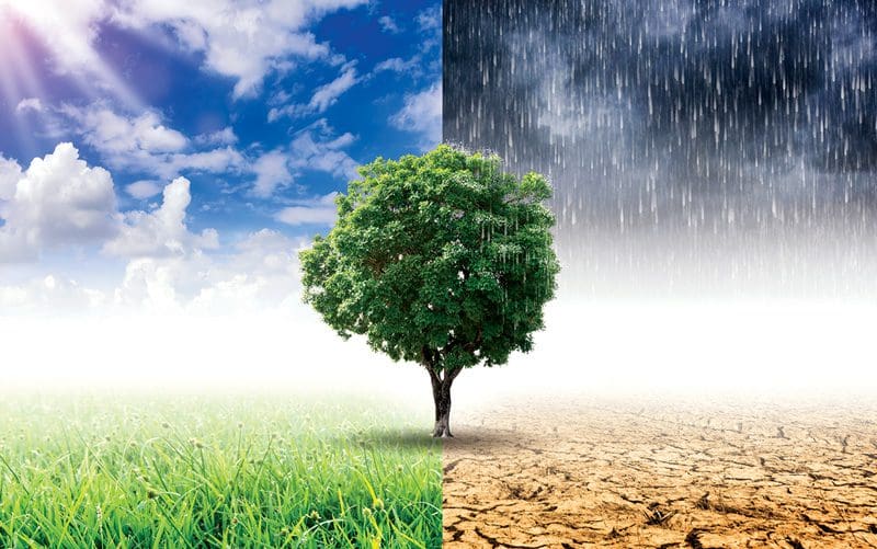
Five factors in climate complexity
Five factors in climate complexity: Latitude, Rainfall, Elevation, Humidity, Ocean Currents and Temperature – Like anywhere in the world, Costa Rica’s climate is affected by five key factors.
1. Latitude
Latitude has the greatest influence on the climate in Costa Rica, as it does in other countries compact in size with multiple climate zones, such as Colombia, Ecuador, Indonesia and Uganda.
Costa Rica extends from 8 to 11 degrees north of the equator in “the tropics” — between the Tropic of Capricorn and the Tropic of Cancer. Parts of the world in this latitude have at least one day of the year when the sun shines directly overhead. That means at noon, nothing casts a shadow. This happens here around April 14 and again around August 18.
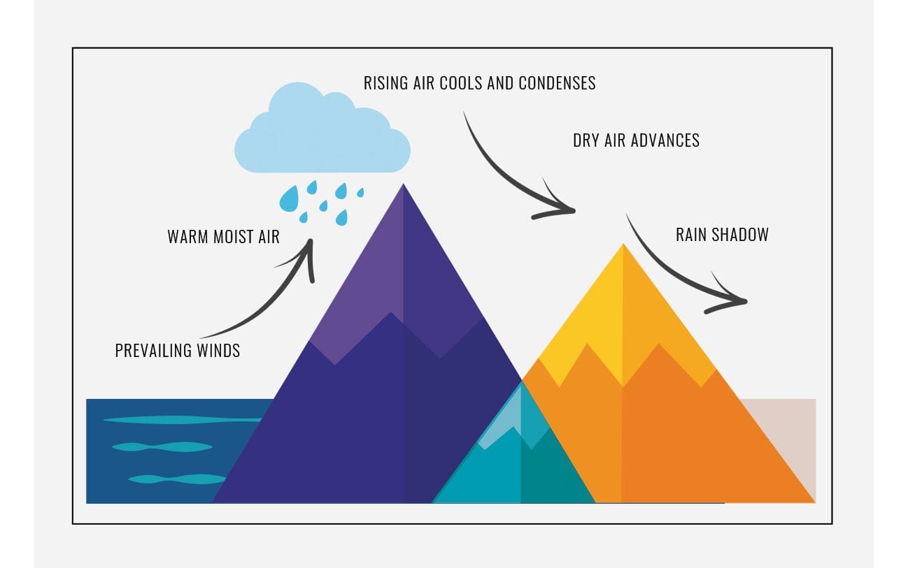
Mountains not only affect temperature but also rainfall. Moist air rising over mountains creates rain. As the clouds move up above the mountains, they eventually lose their moisture, resulting on the other side in what’s called a rain shadow.
2. Rainfall
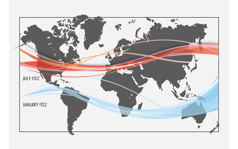
Being in the tropics also affects seasonal rainfall. Costa Rica’s distinct wet and dry periods, known here as winter and summer, are due to the latitude-related weather pattern in the Intertropical Convergence Zone (ITCZ). From ancient sailor lore, we’re familiar with trade winds blowing at certain times of the year, and the doldrums when those seasonal winds stop.
In Costa Rica, these wind currents cause rain to appear first in the southern zone, progressing north until finally, they reach the northern zones in Nicoya and Guanacaste. Drying occurs in the opposite order; conditions and seasons are generally drier and shorter in the north.
This explains why Guanacaste is drier than Osa, and other parts of the country would have similar weather patterns, with a shorter or longer rainy season, if we did not account for the other climate factors such as elevation.
3. Elevation
With Costa Rica being approximately 10 degrees from the equator, why do people in San José sometimes wear jackets or sweaters? Elevation is the climate factor that can make the air chillier.
For every 1,000-foot increase above sea level, the temperature drops about 3.5°F (6.4°C per 1,000 meters). That is why in the mountains temperatures will be about 20 degrees cooler than in Costa Rica’s coastal areas.
The mountainsides that face prevailing winds from the east and northeast are wetter and the opposite slopes are drier. In other words, the Pacific slopes are generally drier than the Caribbean slopes.
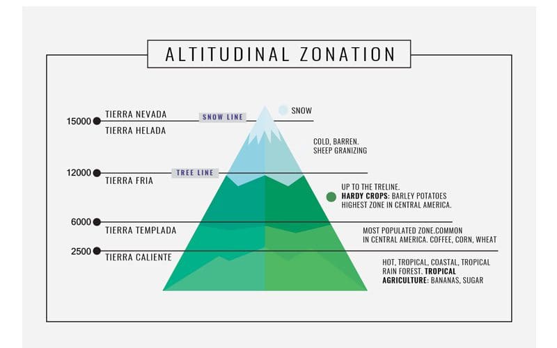
In equatorial Latin America, five different altitudinal zones characterize the types of wildlife and vegetation that can exist. Costa Rica has four of these altitudinal zones, lacking only the highest elevations with permanent frost or snow cover.
4. Humidity
Moisture in the air — humidity — is the penultimate climate factor. The wetter the air, the less the human body can cool itself. That’s why 30°C (86°F) seems much hotter in humid conditions.
Besides affecting how warm it can feel, high humidity also affects the amount of sunlight and habitat conditions for plants and animals. At high altitudes, it feels colder and causes fog, which limits sunlight and at low altitudes the sun is unrestricted in its heat. So the warmer coastal areas of Costa Rica near water feel hotter, and the cooler higher-altitude places where clouds form, like Dota or Poás, will feel colder.
Mountains not only affect temperature but also rainfall. Moist air rising over mountains creates rain. As the clouds move up above the mountains, they eventually lose their moisture, resulting on the other side in what’s called a rain shadow.
5. Ocean Currents and Temperature
Ocean currents are the fifth factor affecting our climate. With the Caribbean being generally shallower, prevailing warm water currents flow south. The opposite occurs in the deeper, colder Pacific currents flowing north.
Air flowing over cold water absorbs less moisture than it does when the water is warm. So generally, with much more moisture coming from the east than from the west, the northeast part of the country is the wettest.
These cyclical currents, especially in the Pacific, form what is commonly known as El Niño. Named by fisherman in Peru who noticed the pattern starting around Christmas time, El Niño occurs when cold Pacific currents oscillate. These currents slow down, the sea temperature rises and the warmer water causes climate changes.
El Niño’s greatest warming impact in Costa Rica reinforces our normal dry season conditions while reducing rainfall during wet season. The last El Niño, ending in 2015, devastated Guanacaste with a severe two-year drought, record high temperatures and forest fires. Weather scientists predict a recurrence of El Niño here in 2019.
What is so unique about the Nicoya Peninsula and the area’s local secret to living a longer life?
Cover Story – Costa Rica is the Happiest Country in the World… Why?
Costa Rican Army Abolished: One more reason for happiness?
Costa Rica Yoga and Wellness Retreats
Yoga Wisdom – Power of Yoga: Yamas and Niyamas
Yogapedia – Vrksasana: Tree Pose
Natural Medicine – CBD Oil: Nature’s Miracle Cure?
Mindfulness: Natural High: Benefits of Nature
Psychological Well Being – Counseling Help in Costa Rica
Eat Well: Costa Rica Superfoods – Nutrient Dense Food
Costa Rica Medical Tourism
Costa Rica Dental Tourism: Veneers – Reason to Smile
Ecotourism in Costa Rica: Sustainable Tourism
Ecotourism Pioneer: Rafael Gallo – Ríos Tropicales
The Osa Peninsula
Ecotourist Road Trip: Sarapiquí
Ecolodges in Costa Rica
Caminos de Osa: Tourism that is helping Costa Ricans
CST Being Green Matters to Diamante Eco-Adventure Park
Grow Sustainably, Build & Live Sustainably in Costa Rica
Behind the Image: Photography as Ecotourism
Building Green and Prove it in Costa Rica
Costa Rica Sustainable Development: Ever Greener
Costa Rica’s indigenous Communities and Indigenous Tribes