Surf Science: Tamarindo Spot Check
- MAR 06, 2017Warning: count(): Parameter must be an array or an object that implements Countable in /home/howlermag/public_html/old/wp-content/themes/new-paper/includes/general.php on line 193
Your Lead Paragrpah goes here
In the previous Surf Science articles, we have explored: how waves are created, the importance of swell period, the different swell producers of Costa Rica, and the weather mechanisms responsible for the famous Papagayo winds. In this article, we will apply what we’ve learned to analyze the location that put Costa Rica on the map as a surfing destination, Playa Tamarindo.
Knowing that many of us reading this are living (at least for the moment) in the Tamarindo area, I figured this would be an appropriate location to analyze. Tamarindo was mostly unknown before some adventurous surfers discovered the wave potential in the 1970s. And then, with the release of The Endless Summer 2 in 1994 starring our friend, Robert August, Tamarindo quickly emerged as a world-class surf destination.

Tamarindo Estuary
But what is it about this particular beach that brings in surfers from around the world? What factors really make this surf spot tick? In this special edition Surf Science article, we will break down the geographical, meteorological, and environmental mechanisms responsible for Tamarindo’s iconic surf.
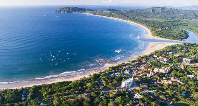
Will will start with Tamarindo’s geographical layout. Unlike many surf spots in Costa Rica, Tamarindo has a unique west-north-west beach orientation that receives both southerly and northerly swells. Year-round surf here is the result of massive low-pressure systems roaring around the high and low latitudes of the Pacific Ocean. Located approximately 2 km offshore, Captain Island, locally known as “La Isla”, plays a significant role in swell refraction and swell shadowing for certain parts of the beach. Adjacent to La Isla lays a submerged reef, or bombora, which acts as an indicator for incoming sets while also refracting swells into Tamarindo Bay. Along the shoreline, Tamarindo’s main features include a sand-bottomed estuary acting as a northern border to Playa Grande, and several lava-rock formations along the beach. All of these locations produce unique waves when different swell events occur.

When analyzing any surf spot, it is critical that we also take into account the Swell Window. Basically, we need to know the range of angles at which a swell can successfully reach the beach. In the example below, you can see Tamarindo receives direct exposure from swells entering the bay from 225° to about 315°. Swells that come from outside this window will have to wrap in, causing wave-size depletion. Isla Capitán also plays a role with southerly swells by shadowing parts of the beach from the brunt of the energy. With Tamarindo’s unique swell window, we are lucky enough to receive consistent swells all year long coming from both hemispheres. Our best seasons being March – September with consistent, long-period SW swells (220° – 235°) and December – March with long period NW (280° – 315)

Tamarindo’s Swell Window
The estuary may be Tamarindo’s defining feature. Separating Tamarindo from Playa Grande, the estuary plays a huge role in sand deposition at the north end of Tamarindo beach. Because the estuary is meandering (long-term movement resembles the slithering of a snake), the sandbars will constantly be changing, creating new line-ups from one season to the next. Anyone remember how the estuary used to emerge by the rocks to Tamarindo’s north creating the epic, pinwheeling right hander? Since then, the estuary has shifted further to the south leaving us with a perfectly fun peeling left hander.

Estuary Right-Hander
Working our way south from the estuary, we have our first lava-thumb reef known as Pico Grande and Pico Pequeño. With a swell window similar to the estuary, Pico Grande and Pequeño will receive both SW and NW swells. Pico Grande is a ledgy right hander crashing over a shallow rock pile on the outside, and can range from mushy peelers to spitting barrels depending on the swell size. Pico Pequeño on the inside of the rocks is the result of the immediate swells wrapping in to create a fun, punchy left and right wedge at high tide just a few meters off the beach. This wave can be quite fun, but rarely makes it above chest high.

Pico Grande
As we move further south to the next lava reef known as Henry’s, our southerly swell window begins to tighten, so only northerly and strong south-west swells will light up this part of the beach. Depending on the exact angle and period of the swell, Henry’s reef in front of Hotel Diria can produce both a left and right-hander on either side of the rocks. Although both waves are quite fickle, they have their share of epic days with a strong northerly swell.
Capitán Suizo is our final stop along the beach. Located in front of Hotel Capitán Suizo, this wave can produce fun (mostly long boardable) peaks that have wrapped around the La Isla right offshore. The beach here will receive both north and south swells. Mostly reserved for beginners and intermediates, Capitán Suizo can produce a lengthy left hander with shorter, punchier rights. The wave is playful on the surface, but there are a few submerged rocks below to be aware of.
Anyone who’s surfed Tamarindo has surely been mesmerized by the reeling lefts and boiling rights on either side of the deserted island offshore. Because of its location, La Isla’s swell window is open to incoming swells ranging from 180 to 320. A quick note: Anyone who surfs here must be to-the-minute aware of the tides if they plan on paddling to and from the beach. I have to admit, I’ve never surfed La Isla (not sure why) but it sure does look like a wave worth the paddle on some days.

“La Isla” NW swell Jan 2017
Thanks for reading! Any questions or topic requests, please send them to Ryan@witchsrock.com
See you out in the water!

